How to Compare Climate Risk Assessment Services: A Practical Guide for Non-Experts
- Apr 23
- 8 min read
In a previous article, we explored the leading free public climate data sources. In recent years, an increasing number of private companies have also started offering climate services. Alongside Callendar, notable players include, for example, Jupiter Intelligence, XDI, Mitiga or Climate-X.
For non-experts, comparing climate risk assessment services can feel overwhelming. This article highlights key features to help you quickly assess the quality of climate data on offer.
Do you need a climatologist to assess your climate data provider’s work?
CDP data, which tracks corporate climate action, shows that in 2024, only one in five companies had used climate projections to assess business risks. Even then, many remained unsatisfied with the results.
Companies using climate projections often voice frustration: non-actionable data, conflicting results, prohibitive costs that force them to narrow their study scope... and, ultimately, no way to verify the findings.
Climate services typically assess low-probability events over long time horizons, making them practically unverifiable for decades. Like all long-term forecasts, their quality doesn’t hinge on future confirmation but on the rigor of their methodology. The problem is that the vast majority of companies do not have in-house experts to evaluate the validity of one scientific method over another. So do you need to hire a climatologist to check the work of your climate data provider?
Not necessarily. This article provides practical guidance to help you assess the quality of climate data. No PhD in climatology required...
First step: Clarify your needs and what the climate service provider offers
In recent years, climate adaptation consulting has grown significantly. Comparing these services can be challenging because climate adaptation encompasses a wide range of activities, each requiring distinct and often unrelated expertise.
Broadly speaking, three main areas can be identified:
Climate exposure assessment: Understanding how climate will evolve in your areas of interest. This requires primarily scientific expertise, sometimes complemented by data science skills, to handle climate data according to best practices. Having a climatologist on the team is essential.
Risk assessment: Translating climate exposure into operational or financial risks. Here, the key skills are sectoral or territorial knowledge. Field presence is often necessary.
Adaptation planning: Designing and implementing risk reduction actions. This step requires a strong understanding of protection techniques for identified risks, as well as change management skills, including stakeholder engagement, awareness-raising, and monitoring.

Your needs may not cover this entire chain. Many companies, for example, already have in-house expertise in weather risk assessment that can be easily leveraged from a climate exposure study.
In fact, it is rare for a single provider to have the expertise to deliver the full process. Callendar, for instance, specializes in climate exposure studies but does not engage in risk assessment or adaptation plans. Conversely, many consulting firms active in adaptation don't actually have an epertise in climatology and rely on climate data obtained from other organizations.
To avoid disappointment, it is essential to clarify your actual needs and ensure your provider has the corresponding expertise.
How to compare climate projections or services without being an expert?
Regardless, reliable climate projections are always essential. If the exposure study is flawed, it will inevitably distort risk assessment and, in turn, the adaptation plan.
For example, if temperature increases at one of your sites are overestimated, your risk assessment will overstate heat-related risks at that site, at the expense of other hazards or locations. This will lead your adaptation plan to prioritize uncessary investments, for example to upgrade cooling systems, using resources that could have been better allocated elsewhere.
To assess the reliability of climate data without expert knowledge, here’s what to watch for:
Identify the source of the climate data
Check for basic scientific best practices
Assess spatial resolution with a critical eye
Make sure that you have access to methodology and intermediate data
Identify the source of the climate data
Let’s start by clarifying a key point: No private company produces climate projections. Only major research centers, often linked to national meteorological services, develop and run global climate models.
Internationally, these research centers coordinate through Coupled Model Intercomparison Projects (CMIP). Even if heavily processed, your climate data will always originate from one of them. You can easily identify the source by checking the emission scenarios used:
CMIP6: The most recent projections, created for the IPCC’s 6th Assessment Report. These are the only ones based on SSP scenarios (primarily SSP1-2.6, SSP2-4.5 and SSP5-8.5).
CMIP5: Projections from the IPCC’s 5th Assessment Report, using RCP scenarios (RCP2.6, RCP4.5, RCP8.5, etc.). Though still widely used, they are becoming outdated, as they date back to the mid-2000s, nearly 20 years old.
CMIP3: Projections from the IPCC’s 4th Assessment Report (there is no CMIP4). These are now largely obsolete and use SRES scenarios (A1, A2, B1, B2).
CMIP5 projections remain popular, partly because many ready-to-use datasets are available. For example, France’s DRIAS platform relies on regionalized CMIP5 projections.
However, it’s important to note that CMIP5 projections are bound to be phased out in the coming years in favor of newer ones. If you want an evaluation that remains valid over time, it’s best to opt for CMIP6 projections directly.
Check for basic scientific best practices
The topic is broad and constantly evolving, but you should at least verify two key points of methodology:
Bias correction: Climate model outputs can contain systematic errors and should never be used directly. Detecting and correcting these errors through bias correction is essential. While choosing a bias correction method is complex, this step is non-negotiable.
Multi-model ensembles: There are many climate models and no single model holds the truth. Exposition studies should always use multiple independent models and assess their convergence. The provided value (typically the median of all model results) carries very different weight if all models agree or if they widely diverge.
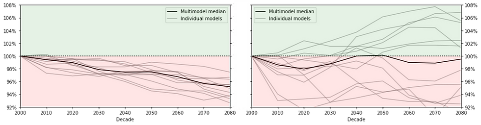
While these two checks don’t guarantee the validity of the results, they can help you flag data that would undermine the credibility of your adaptation effort.
Assess spatial resolution with a critical eye
Spatial resolution has become one of the most highlighted features in commercial climate projection offers, sometimes at the expense of reality. Some providers boldly claim resolutions of a few hundred meters, or even a few dozen meters.
It’s worth remembering that a climate model is fundamentally a weather model: would you trust someone who tells you that their weather forecasts are so precise that they know where it will rain the most in your garden?
For reference, Météo France’s highest-resolution weather model operates at 1.3 kilometers, and even specialist in ultra-high-resolution weather observation, like HD Rain, only claims 500-meter precision.
In most cases, climate projection offers boasting such extreme detail are, intentionally or not, confusing the resolution of the climate projections with that of other physical data (elevation, land use, etc.), which are typically used later in risk assessment.
The resolution of climate projections is inherently limited by the resolution of historical weather data, which is essential for bias correction: you cannot have reliable future climate projections for a location where you lack reliable past weather data. As a result, even when enhanced by downscaling techniques, the spatial resolution is generally on the order of ten kilometers.
Make sure that you have access to methodology and intermediate data
Even if you can’t personally assess the validity of the methods used, your climate data provider should share a detailed methodology and obviously do so before you commit. This methodology should at least address: What data sources are used? What are the key processing steps? And why?
Beyond reliability, climate projections will be embedded in reports and action plans that you’ll likely need to defend to your own stakeholders: investors, banks, insurers, local authorities or government agencies... They, in turn, will want to evaluate the validity of your studies and potentially compare them to their own assessments. A well-documented, accessible, and sourced methodology will be invaluable in these discussions.

Similarly, the provided data should not be limited to final results. Access to intermediate data, such as bias-corrected climate projections, is essential. This is first and foremost an issue of auditability. But it also allows you to reuse the results, for example, to calculate new indicators, without relying on your original provider.
Auditability and transparency are key criteria when choosing a climate service and unlike scientific validity, they are easy to evaluate.
Applying this framework to compare existing climate service offerings
Jupiter Intelligence: A strong solution for finance, but limited for other use cases
US-based Jupiter is one of the most visible private climate solutions on the market. Its platform includes multiple modules focused on physical risk analysis, regulatory compliance, and financial indicator calculations.
Applying our criteria to their ClimateScore Global tool yields the following results:
Data source | ✅ CMIP6 (1) |
Scientific best practices (Bias correction, multi-model uncertainty) | ✅ Yes (1) but not detailled |
Spatial resolution | ⚠️ 90 meters (2) |
Transparency and auditability (methodology and intermediate data) | ⚠️ No |
Jupiter Intelligence’s solution is clearly tailored for banks, insurers, investors, and risk management teams that need to produce regulatory reports (such as TCFD), assess financial risk, and require a synthetic evaluation across many assets. However, their models largely function as "black boxes," producing aggregated risk scores useful for portfolio management but unusable for an engineer who needs to concretely resize a building structure or cooling system.
AXA Climate (Altitude): A platform focused on simplicity
AXA Climate, a subsidiary of the AXA insurance group, offers the Altitude platform for climate decision-making. It is structured around three pillars: physical risk, adaptation strategy and regulatory compliance. The platform is primarily designed for portfolio screening, enabling macro-level diagnostics and prioritization based on aggregated risk scoring.
Data source | ✅ CMIP6 (1) |
Scientific best practices (Bias correction, multi-model uncertainty) | ⚠️ Not detailed |
Spatial resolution | ⚠️ "Up to 30 meters" (2) |
Transparency and auditability (methodology and intermediate data) | ⚠️ No |
Altitude by AXA Climate was designed as a risk management and adaptation tool for businesses. Its positioning leans toward extreme simplification, aiming to cover all ESG issues, such as physical climate risks and biodiversity, within a single platform. This makes it a convenient option for regulatoru disclosure and extra-financial reporting needs, but it may lack the transparency and depth required for other use cases.
Mitiga (EarthScan): Between extreme modeling and limited operational use
The EarthScan platform, initially developed by UK-based Cervest and later acquired by Spain’s Mitiga Solutions, positions itself as a climate risk management solution bridging climate science and business strategy. Specializing in modeling extreme natural hazards (floods, wildfires, storms), the platform offers climate projections for industries, financial institutions, and insurers, delivering outputs such as financial risk reports via Climate Value at Risk.
Data source | ⚠️ CMIP5 et CMIP6 (1) |
Scientific best practices (Bias correction, multi-model uncertainty) | ✅ Yes (1) |
Spatial resolution | ✅ 25 kilometers (2) |
Transparency and auditability (methodology and intermediate data) | ⚠️ No |
EarthScan primarily targets physical climate risk reporting and supports multiple regulatory frameworks (CSRD, TCFD, ISSB, etc.). While the detailed methodology is not publicly available, the shared information suggests a fairly rigorous approach.
ClimateVision: Actionable climate projections for industrial engineering
Developed by Callendar, ClimateVision stands out with its explicit focus on infrastructure and industrial projects. The solution aims to provide climate projections that can be directly applied to technical decisions, such as designing weather-sensitive installations (cooling systems, drains, retention basins, elevated structures, etc.). This level of granularity, when aggregated, can also address other needs, such as climate risk reporting or due diligence.
Data source | ✅ CMIP6 (1) |
Scientific best practices (Bias correction, multi-model uncertainty) | ✅ Yes (1, 2) |
Spatial resolution | ✅ 25 to 5.5 kilometers (2) |
Transparency and auditability (methodology and intermediate data) | ✅ Fully provided (3) |
Unlike the previously mentioned solutions, ClimateVision is not positioned as a regulatory or financial reporting tool but primarily as an engineering solution. In practice, this leads to detailed projections that can meet a company’s full range of needs. However, it may require data reprocessing, and certain hazards required by regulations (such as hail) are not available because no recognized method exists to assess them.
The final and ultimate criterion for choosing your climate service
This overview is not exhaustive. It would be impossible, as dozens of startups emerge every month to tackle adaptation, and new solutions will likely appear tomorrow. However, this comparison shows that different offerings don’t always compete directly. Instead, they often address different needs: some excel in compliance, others in portfolio analysis or in engineering.
You are not acquiring climate data just for the sake of it. This information must help you make decisions.
Ultimately, the most important criterion is this:
Will the data provided actually enable you to make the decisions you need to make?
Do you trust the information you are given?
_________________________________________________________________________________
Still unsure? Let’s talk about it.
Since 2019, Callendar has been a pioneer in climate services in France. Working with major industrial players as well as hundreds of thousands of individuals through our public applications, we can certainly guide you toward the solution that fits your needs.


